For immediate release
For more information, contact
Tammy Snodgrass
or
Caitlin Jones
For immediate release
For more information, contact
Tammy Snodgrass
or
Caitlin Jones
MARIES COUNTY—Maries County will have a public informational meeting on the new floodplain maps June 5, 2025, from 10 a.m. – 12 p.m. at the Maries County Courthouse, 211 4th St., Vienna.
The intent of the meeting is to share the new floodplain maps with the county and answer questions for citizens who currently own property in or near a floodplain.
“I encourage anyone who owns property in or near the floodplain to attend,” said Tammy Snodgrass, Meramec Regional Planning Commission (MRPC) Assistant Director and Environmental Manager. “The new maps have changes that will take some properties out of the floodplain and put others into the floodplain. You will be able to see the new maps and get information from the company that is updating the maps on how the process was implemented. It’s very important to know whether your property is in the flood zone because development in the floodplain has requirements to protect your property from flood damage.”
Maps can also be viewed at the county assessor’s website at https://maries.integritygis.com.
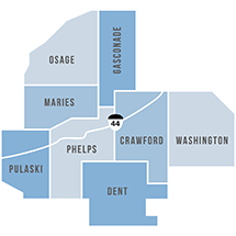
Formed in 1969, MRPC is a voluntary council of governments serving Crawford, Dent, Gasconade, Maries, Osage, Phelps, Pulaski and Washington counties and their respective cities. Mary Heywood, representing the unemployed, serves as chairman of the board. A professional staff of 24 offers technical assistance and services, such as grant preparation and administration, housing assistance, transportation planning, environmental planning, ordinance codification, business loans and other services to member communities.
To keep up with the latest MRPC news and events, visit the MRPC website at www.meramecregion.org or on Facebook at www.facebook.com/meramecregion/.
-30-